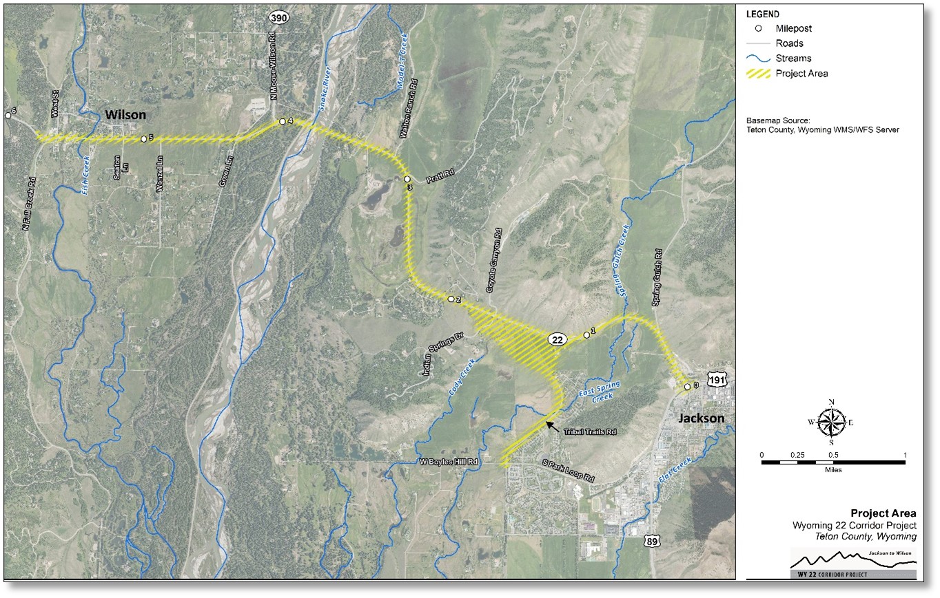
Where is the WY 22 Corridor Project located?
The Wyoming State Highway 22 (WY 22) Corridor Project – Jackson to Wilson is located in Teton County, extending approximately 5.7 miles from the WY 22 Y intersection at Broadway Avenue in Jackson west through Wilson, and extending south to South Park Loop/Boyles Hill Road. A roughly 0.25-mile section of WY 22, from the Y intersection extending west, lies within the Town of Jackson limits.
What is the purpose of this project?
The purpose of this project is to improve safety and mobility for all users and modes of transportation through the approximately 6-mile segment of the WY 22 corridor between Jackson and Wilson.
Why is this project needed?
This section of WY 22 is Wyoming’s busiest and most congested two-lane highway. Daily traffic on WY 22 has increased by 20 percent over the last 10 years. Traffic growth during peak travel hours was even higher during this timeframe, with approximately 30 percent growth in the morning peak hour and 17 percent in the evening peak hour. Project needs include reducing the potential for crashes, reducing peak period travel time, and accommodating existing and future person trips. Without improvements, delay during peak travel hours in both directions of WY-22 will worsen, particularly in the busiest highway segments.
When will the project be completed?
WYDOT plans to complete the NEPA process for the project in Spring 2026. Final design would follow. Construction funding has not yet been identified and therefore is not scheduled.
How much will the project cost and how will it be funded?
A high-level cost estimate will be developed for the Recommended Alternative once it is identified. This cost will be refined as project planning and design progresses. Currently, WYDOT has not identified or programmed any funding for project construction. Further, no specific funding sources have been identified, but future project funding likely would be a mix of federal and state funds. Local funding sources also could be used for specific improvements.
Will a cost/benefit analysis be prepared?
Benefit/cost analysis (BCA) is not a requirement to fulfil either the pre-NEPA or NEPA phases of the project. BCAs have notable limitations because many costs and benefits are difficult or impossible to quantify in monetary terms. (A human life is often used as an example). At this time, WYDOT is not anticipating preparing a cost/benefit analysis.
What is NEPA?
NEPA stands for the National Environmental Policy Act. It requires federal agencies to assess the environmental effects and input from the public of their proposed actions prior to making decisions. For this project, the lead federal agency is the Federal Highway Administration (FHWA). Three “classes of actions” prescribe the level of documentation required in the NEPA process: Categorical Exclusions, Environmental Assessments, and Environmental Impact Statements. In consultation with FHWA, WYDOT will determine the appropriate level of NEPA documentation or class of action after early project activities, termed pre-NEPA, have been completed.
What is pre-NEPA, and why is it being done?
WYDOT is conducting early project activities to inform the decision on what type of NEPA class of action will be appropriate. These activities include project scoping, traffic and safety analysis, environmental resource investigation, and, later, alternatives evaluation.
What environmental impacts will be evaluated?
The NEPA study conducted for this proposed project will evaluate potential impacts to an array of environmental resources. These range from natural resources such as wildlife, wetlands, and water quality to human or social environmental resources including visual resources, air quality, historic properties, noise, parks, and Section 4(f) properties.
What is Section 4(f)?
Section 4(f) of the Department of Transportation Act of 1966 (as codified at 23 U.S. Code [U.S.C.] § 138 and 49 U.S.C. § 303) requires that transportation projects avoid using land from publicly owned parks, recreation areas, wildlife and waterfowl refuges, and historic sites, unless there are no feasible and prudent alternatives. The authority to administer Section 4(f) and make Section 4(f) approvals resides with the Secretary of the U.S. Department of Transportation (DOT) and, therefore, FHWA ultimately will decide which resources qualify as Section 4(f) properties for this project.
How will this project affect collisions with wildlife?
Approximately one-quarter of all the crashes on WY 22 in the project area over the past decade were wildlife-vehicle collisions (WVC). WYDOT is currently constructing four wildlife crossing structures, fencing, and jump outs within and adjacent to the WY 22 corridor as part of the Snake River Bridge project. WVC improvements proposed as part of the WY 22 project would tie in with improvements under construction as part of the Snake River Bridge project, creating a comprehensive WVC mitigation system designed to substantially reduce the number of WVC.
Will there be wildlife fencing on this project?
Wildlife fencing will be considered as part of this project.
Will the project consider safety improvements?
Yes. Based on WYDOT’s four-tiered safety rating system, WY 22 has the lowest or worst rating for critical crashes compared to similar roads statewide. It also has a high number of wildlife-vehicle collisions (WVCs), particularly with large mammals. Alternatives will be developed and evaluated based on how well they address the purpose and need of the project. Identified safety needs include reducing crashes, improving reliable access for emergency response vehicles, improving resiliency of the road, and improving intersection safety.
How will this project affect my property?
Previous studies have recommended widening WY 22 in some locations. This study will identify any potential right-of-way impacts that would result from the proposed project and identify measures to minimize those impacts. Unavoidable right-of-way acquisitions will be conducted in conformance with the Uniform Relocation Assistance and Real Property Acquisition Polices Act.
Will this project increase noise levels?
- A noise study will be done to see how the proposed project will affect the noise levels around noise-sensitive properties in the area.
- Noise-sensitive properties are places where people are likely to be affected by noise, such as homes, schools, and parks.
- To determine if a project will have noise impacts, the project team will compare the existing noise levels at noise-sensitive properties with future noise levels at those properties after the project is built. This will help to determine if the project will have any negative impact on noise levels.
- If the noise study finds that the project will have negative impacts on noise levels, the project team may need to take steps to mitigate the noise, such as planting trees or installing noise barriers.
How will the project change the landscape and views?
This will vary based on alternative. Considering the importance of scenic resources within the project area, WYDOT will compare potential visual impacts from different improvements and alternatives as part of the alternatives evaluation. A formal visual impact assessment (VIA) following FHWA requirements will be required during NEPA. WYDOT will evaluate ways to minimize and mitigate visual impacts that may result from the proposed improvements.
What alternatives are being considered?
With input from an advisory committee formed after Public Meeting #1, the project team has started evaluating alternatives. For a description of the Alternatives evaluation process and alternatives being considered please see Alternatives.
How can I stay involved and learn more about the project?
- Get more information and sign up for email updates at the project website: wy22corridor.com
- Email the project team with questions or concerns at contactus@wy22corridor.com
When will more public meetings be held?
WYDOT held the second set of public meetings in February 2024. The meeting displays are available on the project website (click here). The first public meetings were held in June 2023, the meeting displays are also available on the project website (click here). Future public meetings will be held at key points in the process to provide project information and updates and obtain public comments. The public will have the opportunity to provide comments on the alternatives carried forward into Level 2 screening at the third set of public meetings, tentatively planned for winter 2025. Meetings will be announced a minimum of 2 weeks prior to each meeting.
How will traffic delays during construction be handled?
This will depend on what alternative is recommended for construction. Later in the process, traffic analysis will help identify how construction should be implemented, including any potential traffic re-routes, lane closures, and detours. WYDOT public involvement staff will work closely with construction contractors to understand and communicate any construction activities that impact travel to the public in advance of traffic disruptions.
How will the project affect the START bus routes on WY 22?
The traffic analysis portion of the project will consider bus use through the corridor. Final effects will not be known until an alternative is selected. In general, any improvements to congestion along the corridor should also improve transit times.
In general, any improvements to congestion along the corridor should also improve transit times. Will the project consider bicycle and pedestrian improvements?
Yes. WYDOT recognizes the importance of bicycle and pedestrian connectivity in the WY 22 corridor from both a recreational and transportation perspective. One of the needs of the project is to promote multimodal (pedestrian, bicycle, transit) travel options for the project corridor. Therefore, improvements to bicycle and pedestrian connectivity will be considered in developing and evaluating project alternatives.
Will the project raise the speed limit on WY 22?
Speed limits range from 25 mph to 55 mph along the project corridor, depending on the roadway segment. WYDOT does not anticipate any changes to the existing speed limits as a result of the proposed improvements.
How will the project address difficulties residents face entering the highway due to heavy traffic? Will there be new traffic lights or roundabouts for safer access and exits?
The project aims to enhance both mobility and safety on WY 22 by addressing the congestion that causes long lines of vehicles during peak travel times. This will help residents access the highway more easily. The primary issue is the heavy traffic on WY 22, which forms continuous lines of vehicles, or platoons, that make it difficult for vehicles to enter from side streets or driveways. A detailed analysis of current traffic conditions and projected future volumes will guide the identification of measures to provide safe and efficient access to and from WY 22.
Is it possible to explore an underpass on WY 390 near Anderson Lane for west side access?
Yes, WYDOT is open to evaluating the possibility of an underpass. Pathway facilities under state highways can also be authorized through encroachment permits and cooperative agreements with WYDOT, as seen throughout other Teton County projects.
What measures can improve safety for people crossing WY 390 to the west side, such as surface treatments or flashing beacons?
Due to WY 390’s heavy and fast traffic, at-grade crosswalks with flashing beacons or buttons could create a false sense of security for bicyclists and pedestrians, disrupt traffic flow, and therefore are unsafe. Grade-separated pathways can be built under encroachment and cooperative agreements with WYDOT.
Is there a possibility to connect a pathway across WY 390 at Millwood subdivision?
WYDOT is open to evaluating a grade-separated crossing at this location.
How will this project affect pathways along WY 22? Will they be included?
WYDOT recognizes the importance of the pathways along WY 22 as a key transportation resource and is considering all modes of transportation in the corridor as part of the project’s purpose to improve safety and mobility in the project area. The project’s Purpose and Need Statement cites the need to maintain bicycle and pedestrian connectivity along the corridor.
A pathway along WY 22 will be included in the WY 22 Corridor Project and has been shown on alternative typical sections presented to stakeholders and the public. Some realignment of pathways might be required; this will be evaluated.
The project’s alternatives process categorizes pathway improvements as supplemental elements. The Alternatives page on the project website defines this term and refers visitors to the public meeting #2 exhibits and handout materials for a complete list of supplemental elements.
What improvements can be made for pedestrian and bicycle safety in downtown Wilson, such as crosswalks with beacons?
A separate project– Teton Mobility Corridor Improvements BUILD Grant Project –will construct improvements in Wilson. This includes two crosswalks, one at Fall Creek and one near Ida Street. WyDOT will evaluate whether additional improvements might be needed. Any traffic control devices, including beacons, must be evaluated with respect to warrants prior to consideration.
Why is the Tribal Trail project included in the WY 22 Corridor Project?
Teton County Commissioners wanted to combine the Tribal Trail project with the WY 22 Corridor Project so that WYDOT can evaluate potential transportation-related improvements to the WY 22 corridor in a comprehensive and coordinated manner. Teton County and WYDOT also received public comments that the Tribal Trail project should be analyzed along with the WY 22 Project. Some of the benefits of combining the projects include coordinated analysis and planning, increased opportunities for federal funding, and additional opportunities for public input through WYDOT’s robust public outreach process.
How will the solutions from Wilson’s safety and design committee be incorporated into the improvements on WY 22?
The Wilson Safety and Design Committee is encouraged to participate in the public engagement process for the WY22 Corridor Project Study. WYDOT has and will continue to consider input from the Wilson Advocacy Steering Committee.
What steps can be taken to make it easier to get on and off of WY 22 in Wilson?
The Teton Mobility Corridor Improvements (TMCI) project would improve access to and from WY 22 by adding a center refuge lane on WY 22 in Wilson from the commercial core to Fish Creek Bridge. The Wilson Multi-modal Study explored other solutions, but many were deemed infeasible due to the lack of a local street network and high WY 22 traffic volumes. The findings from the Wilson Multimodal Study will be considered in the Level 2 alternatives evaluation phase of the WY 22 Corridor Project.
What are the plans for a linkage study on WY 390?
WYDOT completed the Wyoming Highways 22 and 390 Planning and Environmental Linkages (PEL) Study in 2014. At present, WYDOT is not planning on conducting another PEL for WY 390.
Is the “do nothing” option completely off the table for the WY 22 corridor project?
No. A “do nothing” or No Build Alternative is included in the alternatives currently being evaluated and will be evaluated in greater detail during the NEPA phase.
What is the current status of lane alternatives in the WY 22 corridor study?
Please refer to the Alternatives page of the project website for status. The range of alternatives was developed in coordination with the town, county, and Project Advisory Committee then presented to the public at two public meetings in February 2024.
How will condemnation or property acquisitions be determined for the WY 22 corridor project if WYDOT or Teton County cannot obtain the necessary easements?
The potential need for property acquisitions will be identified as alternative design advances and will be determined during the final design and right-of-way phases.
Do all current alternatives being considered include the Tribal Trail connector?
No. The Tribal Trail Connector is a core concept that advanced to Level 2 evaluation, along with a No Build Alternative that would not extend Tribal Trail Road to WY 22.
What impact do BUILD grant projects have on the WY 22 Corridor Project Study alternatives?
The Teton Mobility Corridor Improvements BUILD Grant Project includes multimodal improvements along the ID-33/WY-22 corridor. These improvements are included in the WY 22 Project’s No Build Alternative. Within the project corridor, WYDOT will look at improvements to complement and supplement the BUILD improvements, if needed to meet the Purpose and Need.
For segment 3, why are the only options “no action or 3-lane”? Why is “2-lane low build” option through Wilson not being considered?
A 2-Lane Low Build alternative originally was not considered in Segment 3 because a center turn lane will be constructed as part of the BUILD grant project. Based on public comment and further evaluation, WYDOT now will consider a 2-Lane Low Build alternative in the Segment 3 portion where a center turn lane would not be added to WY 22–generally west of Fish Creek to HHR Ranch Road.
Is it possible to designate Highway 22 as a Scenic Byway?
The designation of Highway 22 as a Scenic Byway would depend on the specific criteria and procedures established by the National Scenic Byways Program. The scenic byway program is typically geared toward longer corridors and promoting tourism. Therefore, the WY 22 project corridor may not be a good fit for the program.
Will this project address issues on WY 390?
No. This project only includes the WY 22 corridor. WYDOT’s PEL (reference) evaluated WY 390 and Teton County is considering an updated study on this corridor.